Belgium has participated in ESA's navigation programmes since the implementation in 1999 of the GalileoSat programme, which was ESA's contribution to the definition and validation phase of the Galileo satellite positioning programme developed by the European Commission.
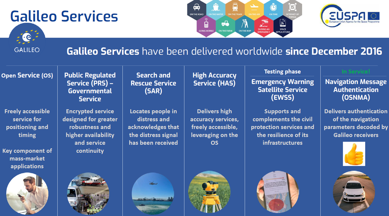
More than five billion users are already benefitting from Galileo. The programme has been providing global navigation services, not just a single open signal, but a suite of differentiated services for different user needs. It has grown into a multi-layered European system, offering both open and specialised services for everyday users, governments, safety-of-life operations, and high-precision industries.
The European Space Agency (ESA) has established a comprehensive and strategically focused portfolio of activities to address the rapidly evolving PNT landscape across the entire value chain. These initiatives designed to enhance European strategic autonomy in PNT infrastructure are built around two key pillars: the Navigation Innovation and Support Programme (NAVISP) and Future Navigation (FutureNAV).
ESA Navigation Innovation and Support Programme (NAVISP)
NAVISP is an important driver for the overall European GNSS landscape, capable of leveraging both ESA expertise gained through Galileo, EGNOS, other navigation programmes and the existing industrial base of the European navigation sector. Since the initiation of the programme in 2016, Belgium has been a participating state in NAVISP.
The main objective is to facilitate innovative propositions beyond the exclusive use of satellite navigation signals and develop competitive industrial capabilities to complement, upgrade or replace current PNT technologies.
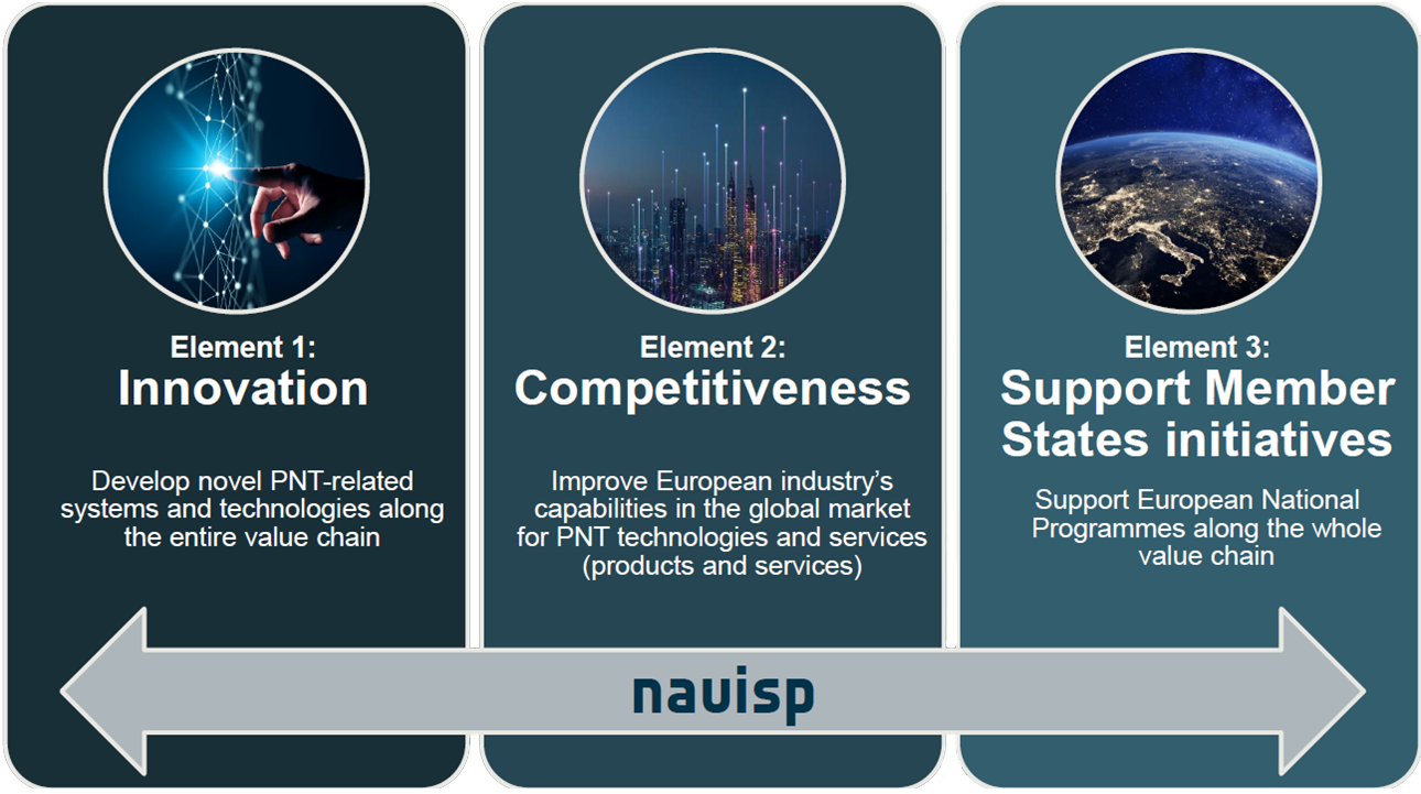
The NAVISP programme is structured according to three elements
Element 1: Innovation in satellite navigation
NAVISP Element 1 aims to develop innovative techniques, technologies and systems for new PNT concepts, generally at a lower TRL.
The specific objectives of this Element are:
The tenders under Element 1 are populated via a yearly workplan and are fully funded by ESA.
Element 2: Competitiveness
NAVISP Element 2 aims to maintain and improve the capabilities and competitiveness in the global market for satellite navigation and, more broadly PNT technologies and services.
The activities may address completely new products of a disruptive nature, may be an upgrading or improvement of an existing product or may address a continuation of an activity funded in another framework within another European institutional programme, a national programme or an industrial/academic research programme. The activities shall aim at resulting in a product ready for commercial exploitation.
The pre-commercial nature of this programme element requires a co-funded approach. Proposals are issued through a continuous open call capable of stimulating unsolicited proposals.
Element 3: Support to Member States
NAVISP Element 3 is focused on priorities and aims at supporting national navigation activities along the whole value chain.
Element 3 configures as an ad-hoc support element, which is envisaged per country and possibly per domain, for the development and promotion of products, applications and services based on GNSS and more widely on PNT systems.
The institutional nature of this programme Element calls for a fully funded approach.
FutureNAV
The FutureNAV Programme anticipates and validates future Positioning, Navigation and Timing (PNT) system concepts and upstream technologies. It is supporting European industry competitiveness on both upstream and downstream space-based PNT markets in response to PNT market needs and opportunities enabled by emerging technological trends. The programme consists of three components.
Component 1: LEO-PNT
LEO-PNT represents an emerging complementary technology based on satellites operating at a lower altitude. The low orbit compared to traditional GNSS constellations offers key added value, including stronger signals, lower latency, and improved performance in complex or contested environments. LEO PNT Celeste is the Galileo daughter mission providing a new low Earth orbit layer of PNT satellites to enhance Galileo’s resilience and complement its capabilities. It will assess how a low Earth orbit fleet can work in combination with Galileo, EGNOS and other GNSS in a multi-layer approach to optimise the provision of services, increasing overall PNT robustness and enabling new services.
Component 2: Genesis
Genesis brings the four space-based geodetic techniques (GNSS, VLBI, SLR and DORIS) together aboard a single well-calibrated satellite. This will result in a unique dynamic space geodetic observatory. The mission will contribute to a significant improvement of the International Terrestrial Reference Frame which provides a coordinate system for the most rigorous navigation applications on our planet.
The combination of advanced technologies for precise orbit determination and timing as well as the scientific exploitation of GNSS signals open new major opportunities for relevant innovative in-orbit scientific experiments in the fields of Earth sciences (including geodesy, geophysics and GNSS remote sensing of atmosphere, land, ocean and ice), fundamental physics, astronomy and time metrology.
Component 3: Demonstrators
FutureNAV Component 3 - PNT Demonstrators supports the development and in-orbit validation of innovative positioning, navigation and timing technologies. This component prepares and matures new PNT system concepts through early mission studies and technology pre-development activities.
Current demonstrators within this component include OpSTAR and NovaMoon, which explore new PNT capabilities in space, as well as studies for additional future demonstrator missions.
Corneel Bogaert
Ruimtevaartonderzoek en -toepassingen